| |
Atlas routiers
FRANCE
- Michelin Regional Map
Carte routière - Road map - Country
maps - Länderkarten |
|
|
| |
|
|
| |
|
|
|
 Les cartes "REGIONAL",
de couleur orange, couvrent un pays par grandes régions, avec le réseau
routier principal et secondaire (échelle du 1/140.000 au 1/2.400.000).
Les cartes "REGIONAL",
de couleur orange, couvrent un pays par grandes régions, avec le réseau
routier principal et secondaire (échelle du 1/140.000 au 1/2.400.000).
 Orange REGIONAL
maps cover the main regions of the country, showing primary and secondary
road networks (scale 1:140,000 to 1:2,400,000)
Orange REGIONAL
maps cover the main regions of the country, showing primary and secondary
road networks (scale 1:140,000 to 1:2,400,000)
 Die Regionalkarten
(Orange) zeigen die Haupt- und Nebenstrecken von einzelnen Regionen (Maßstab
1:140 000 bis 1:2.400 000).
Die Regionalkarten
(Orange) zeigen die Haupt- und Nebenstrecken von einzelnen Regionen (Maßstab
1:140 000 bis 1:2.400 000).
 Los Mapas Regionales
(de color naranja) abarcan las grandes regiones de un país e incluyen la
red principal y secundaria de carreteras (escalas de 1/140 000 a 1/2 400
000).
Los Mapas Regionales
(de color naranja) abarcan las grandes regiones de un país e incluyen la
red principal y secundaria de carreteras (escalas de 1/140 000 a 1/2 400
000).
 Le Carte Regionali,
di colore arancio, si riferiscono a una o più regioni di un paese, delle
quali riportano la rete stradale principale e secondaria (scala da
1/140,000 a 1/2,400,000
Le Carte Regionali,
di colore arancio, si riferiscono a una o più regioni di un paese, delle
quali riportano la rete stradale principale e secondaria (scala da
1/140,000 a 1/2,400,000
|
|
|


Meurthe-et-Moselle - 54

Meuse - 55
Moselle - 57
Bas-Rhin - 67
Haut-Rhin - 68
Vosges - 88 |
Alsace, Lorraine
Carte REGIONAL Michelin
1/275.000 - 1cm = 2.75km
Plan de Metz
Plan de Strasbourg
| Zone
d'emprise de la carte |
 |
| 1/275000
- 1cm = 2.75km |
Meurthe-et-Moselle - Meuse - Moselle - Vosges
- Bas-Rhin - Haut-Rhin
Michelin Regional Map -
France
Editeur : Michelin Editions
Carte routière et touristique |


 |
|
|


|
| |
|
|

|
| |
|
|

|
| |
|
|

Cher
-18
Eure-et-loir - 28
Indre
- 36
Indre et
Loire - 37
Loir-et-Cher
- 41
Loiret - 45 |
Centre
Carte routière : N° 518
Carte REGIONAL Michelin
- France1/300.000 - 1cm =
3km
Cher - Eure-et-Loir - Indre - Indre-et-Loire -
Loir-et-Cher - Loiret
Centre - Berry,
Nivernais
Carte routière : N° 11519
Carte REGIONAL Michelin
- France
| Zone
d'emprise de la carte |
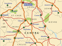 |
| 1/200000
- 1cm = 2km |
An annually updated road map of
Berry-Nivernais, covering the main and secondary road networks across the
region. Scale: 1/200,000 - 1cm=2km Legend/Key in two languages (French,
English)
Centre / Berry-Nivernais
Michelin France, Map No. 519 |


|
|
|

Ardennes - 08
Aube - 10
Haute-Marne - 52
Marne - 51
|
Champagne, Ardennes
Carte routière : N° 11514
Carte REGIONAL Michelin
- France1/200.000 - 1cm = 2km
| Zone
d'emprise de la carte |
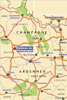 |
| 1/200000
- 1cm = 2km |
An annually updated road map of Champagne and
Ardennes, covering the main and secondary road networks across the region.
Scale: 1/200,000 - 1cm=2km Legend/Key in two languages (French, English)
Champagne / Ardennes
Michelin France, Map No. 514 |
|
|
|

 |
| |
|
|

 
|
Forêt-Noire, Alsace,
Vallée du Rhin
Oberrhein Schwarzwald,
Carte REGIONAL Michelin
Légende en : Anglais Allemand Italien
Français
| Zone
d'emprise de la carte |
 |
| 1/200000
- 1cm = 2km |
Foret Noire-Alscace
(Black Forest)
Michelin France, Map No. 516
An annually updated road map of the Black
Forest and Alsace, covering the main and secondary road networks across the
region. Scale: 1/200,000 - 1cm=2km Legend/Key in four languages (French,
English, German, Italian)
Michelin France, Map No. 516
|
|
|
|

Paris - 75
Seine-et-Marne - 77
Yvelines
- 78
Essonne - 91
Hauts de Seine - 92
Seine-Saint-Denis - 93
Val-de-Marne - 94
Val-d'Oise - 95 |
Île-de-France
Atlas routiers
Michelin ATLAS REGIONAL -
FranceEssonne - Hauts-de-Seine - Seine -
Seine-et-Marne - Seine-Saint-Denis - Val-d'Oise - Val-de-Marne -
Yvelines
1/250.000 - 1cm = 2.5km
| Zone
d'emprise de la carte |
 |
| 1/250000
- 1cm = 2.5km |
Légende en : Anglais Français
An annually updated road map of the
Ile-de-France, covering the main and secondary road networks across
the region. Scale: 1/200,000 - 1cm=2km Legend/Key in two languages
(French, English) Michelin
France, Map |
|
|
|

|
| |
|
|
|
| |
|
|
|
| |
|
|
|
| |
|
|


Alpes-de-Hte Provence
Hautes-Alpes
Alpes-Maritimes
- 06
Bouches-du-Rhône
Var - 83
Vaucluse
- 84
|
Provence Côte d'Azur
Carte routière :
Carte REGIONAL Michelin
1/275.000 - 1cm = 2.75
km
| Zone
d'emprise de la carte |
 |
| 1/275000
- 1cm = 2.75km |
An annually updated road map of Provence and
the Cote d'Azur, covering the main and secondary road networks across the
region. Scale: 1/200,000 - 1cm=2km Legend/Key in four languages (French,
English, Italian, German)
Zeichenerklärung auf : Englisch Deutsch
Italienisch Französisch
Legenda in : Inglese Tedesco
Italiano Francese
Editeur : Michelin Editions
|
|
|
|

Ain - 01
Ardèche
- 07
Drôme
- 26
Isère - 38
Loire - 42
Rhône
- 69 |
Rhône-Alpes
1:300 000Plan de Lyon - City map of Lyon
Carte REGIONAL Michelin
1/300.000 - 1cm =
3km
An annually updated road map of Provence and
the Rhône-Alpes, covering the main and secondary road networks across the
region. Scale: 1/300,000 - 1cm=3km Legend/Key in four languages (French,
English, Italian, German)
Zeichenerklärung auf : Englisch Deutsch
Italienisch Französisch
Legenda in : Inglese Tedesco
Italiano Francese
Editeur : Michelin Editions
- France |
|
|
|


MIO 168 GPS
|
|
|
|
|
|
|
|
|
|
 |
|
|


 |
|
 |


 CartoExploreur
3 est le complément logiciel indispensable de votre
GPS. Il vous permet de
localiser et d'afficher sur l'écran de votre
CartoExploreur
3 est le complément logiciel indispensable de votre
GPS. Il vous permet de
localiser et d'afficher sur l'écran de votre