| |
Préparez vos
voyages et séjours en
Afrique - Africa

Cartes
pays : Afrique - Country maps Africa - Länderkarten
Carte Nazionali - Mapas de Países
|
|
|
| |
|
|


Tunisie
- Tunisia
Tunisien |
 Carte routière : Algérie -
Tunisie, N° 11743
Carte routière : Algérie -
Tunisie, N° 11743
Plan d'Alger
Plan de Tunis
| Zone
d'emprise de la carte |
 |
| 1/1000000
- 1cm = 10km |
Légende en : Anglais Arabe Français
 Carte Algeria / Tunisia
Map Carte Algeria / Tunisia
Map
A road map of Algeria and Tunisia, covering
the major road networks across the region. Scale: 1/1,000,000 - 1cm=10km
Legend/Key in three languages
Michelin - Carte - Atlas - carte
|


 |
|
|

|
Carte routière : Afrique Nord et Ouest, N° 11741
1 / 4000.000
Algérie, Libye, Maroc,
Tunisie, Mauritanie, Mali, Niger, Nigeria, Guinée, Tchad, Cameroun, Cote
d'Ivoire, Togo, Ghana, Gambie, Burkina Faso, Bénin, Liberia, Sierra Leone, Sénégal,
Centre Afrique
| Zone
d'emprise de la carte |
 |
| 1
/ 4000.000 - 1cm = 40km |
Légende en : Anglais Allemand Arabe Italien Français
Michelin Africa North & West Map
Algeria, Morocco, Libya,
Mauritania, Mali, Niger, Nigeria, Chad, Cameroon, Togo, Ghana, Cote
d'ivoire, Guinea Bissau, Sierra Leone, Liberia, Benin, Burkina Faso, Tunisia,
Senegal, The Gambia
Michelin Road Map. Place name index - Main
road map with details of road conditions and climate Key in: French English
Arabic 1:4,000,000
Editeur : Michelin -
Carte - Atlas - carte
|
|
|
|
|
| |
|
|

 
|
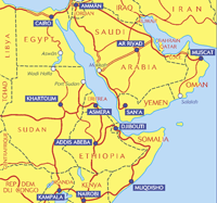
Carte routière : Afrique Nord et Est - Arabie, N° 11745
1 / 4.000.000
Egypte, Erythrée, Soudan,
Ethiopie, Kenya, Arabie Saoudite, Irak, Iran, Yemen
Légende en : Anglais Allemand Arabe Italien
Français
| Zone
d'emprise de la carte |
 |
| 1/4000000
- 1cm = 40km |
Michelin Africa Northeast & Arabia Map
Egypt, Eritrea, Sudan,
Ethiopia, Kenya, Sausi Arabia, Iraq, Iran, Yemen
A road map of Northeast Africa and Arabia, covering the major road
networks across the region. Scale: 1/4,000,000 - 1cm=40km Legend/Key in
three languages
Editeur : Michelin -
Carte - Atlas - carte
|
|
|
|

|
Carte routière : Afrique Centre et Sud - Madagascar, N° 11746 1 / 4.000.000
Légende en : Anglais Français
| Zone
d'emprise de la carte |
 |
1
/ 4.000.000
1cm = 40km |
Michelin Africa Central, South, and Madagascar Map
A road map of Central and South Africa and
Madagascar, covering the major road networks across the region. Scale:
1/4,000,000 - 1cm=40km Legend /
Key in two languages (French and English)
Gabon, Congo, Zaire,
Uganda, Kenya, Tanzania, Angola, Zambia, Malawi, Namibia, Botswana,
Zimbabwe, Mozambique, South Africa, Lesotho, Swaziland
Editeur : Michelin -
Carte - Atlas - carte
|
|
|
|

|
| |
|
|

|
| |
|
|
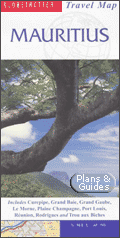

Mauritius
Ile Maurice
|
Mauritius Travel Map
Scale: 1:80,000
The handy pocket-size guide is packed with useful information, tips and
recommendations, accompanied by colour photographs, charts and maps for
the first-time traveller who wants to experience the major highlights that
Mauritius has to offer. This travel book surpasses other guides in that it
incorporates essential information in an easy-to-carry and easy-to-read
format that is attractive and useful at the same time.
It provides a visitor with an invaluable introduction to Mauritius by
concisely highlighting the region's 'must see' areas in a practical and
user-friendly format, thus encouraging the tourist to make the most of his/her
available time.
All the essential information you need to get around an unfamiliar
region is compacted into useful and practical 'At-a-Glance' sections at
the end of each chapter.
The fold-out map of Mauritius is ideal for tourists and visitors. In
addition to the main map of Mauritius, which highlights scenic routes, it
features 11 detailed area maps and 3 town plans.
Editeur : New Holland Publishers
Travel / road maps & atlases
|

|
|
|

|
| |
|
|
 |
| |
|
|

Zambie
Zambia
Sambia |
Sambia - Zambia, Freytag
Berndt Autokarten Zambie 1:2 200 000
Zambia Road Map 1:2,200,000
Sambia - freytag & berndt
Scale - Maßstab: 1:2
200 000
Autokarte, road map, carte routière, carta stradale
Editeur Freytag Et Berndt
|
|
|
|

Zimbabwe
Simbabwe
Zimbabué |
Zimbabwe Travel Map
Globetrotter Travel Map Zimbabwe: Includes Bulawayo, Chimanimani, Chipinge,
Gonarezhou, Harare, Hwange, Lake Kariba, Mana Pools, Matobo, Nyanga and
Victoria Falls
Scale: 1:1.100.000
The Globetrotter Travel Map of Zimbabwe caters specifically for the needs
of tourists and visitors who are new to a destination.
In addition to the main map of Zimbabwe, areas of special interest are
shown in greater detail. Features include accommodation and places of
interest.
Distance and climate charts enable travellers to plan their visits, while
stunning photographs conjure up the atmosphere of the country.
Where applicable, the highlighting of scenic routes, language tips and
calendars of events are provided; Town Plans: Harare and Bulawayo; Area Maps:
Hwange, Nyanga, Victoria Falls, Zimbabwe Ruins, Lake Kariba, Matobo National
Park, Mana Pools, Chimanimani and Chlpinge, Gonarezhou National Park; Scale(main
map): 1: 1,100,000
Editeur : New Holland Publishers
Travel / road maps & atlases
|
|
|
|
|
| |
|
|
|
|
|
|
|

|
| |
|
|
|
| |
|
|
|
| |


|
|
|


![Le Seigneur des Anneaux - Le Retour du Roi [Version longue] - Coffret Collector 5 DVD](../pub/pub_cart_070_100_seigneur.gif)


