| Royaume-Uni
- United Kingdom Carte routière - Mapas de países - Kaart |
| Royaume-Uni
- United Kingdom Carte routière - Mapas de países - Kaart |

|
Carte routière :
Grande-Bretagne - Irlande, N°11713
United Kingdom - Ireland
Michelin Great Britain & Ireland Map Liaisons maritimes An annually updated road map of Great Britain and Ireland, covering the major road networks across the region. Scale: 1/1,000,000 - 1cm=10km - 1in : 15.8 miles Legend/Key in four languages (English, French, German, Dutch) Michelin Map - Carte Michelin |
|
|||


![]()
Hôtels et Réservations d'hôtel par venere.com, appartements, gîtes ruraux, voyages et hébergements.
Hotels and hotel reservations by venere.com, apartments, bed and breakfast, travel and
lodgings.
Hotels und Hotelreservierungen von venere.com, Wohnungen, bed and breakfasts, reisen und
Unterkünfte.
Cerca la tua struttura in Europa: Hotels, Appartamenti, Agriturismo, Bed and Breakfast.
Encuentre su alojamiento en Europa: Hoteles, Apartamentos, Casas Rurales.

|
Streetwise Map Plan de Londres La ville et le métro de Londres. De Notting Hill à Westminster, tout le centre de Londres y figure. Plastifié, clair, lisible, esthétique, pratique et complet (index avec liste des rues, hôtels, sites touristiques, parcs, musées, monuments, salles de concert, shopping, etc.).
Laminated for durability, accordion folded to fit in your pocket or purse, Streetwise (r) gives you London in a clear, concise, and convenient format. City map - Town Plan |
|

|
by Streetwise Maps Plan de ville Edinburgh La ville, la région d'Edimbourg, ainsi qu'une carte de l'Ecosse. Plastifié, clair, lisible, esthétique, pratique et complet (index avec liste des rues, hôtels, sites touristiques, musées, monuments, lieux de culte, les parcs et jardins, shopping, etc.).
Laminated for durability, accordion folded to fit in your pocket or purse, Streetwise (r) gives you Edinburgh in a clear, concise, and convenient format. City map - Town Plan |
|

| Royaume-Uni - Reino Unido - Angleterre - England | ||
| Photos |
Articles |
Détails et |

|
Grande-Bretagne -
Irlande n° 122, 1/300000 Carte routière 59 plans de villes, avec cartes des grands axes routiers, liaisons maritimes. Travel and tourism |
|

|
Motoring
Atlas Great Britain and Ireland, n°96
(Mini 11,6 cm x 16,5 cm). Place name index - Scale 1:1 000 000 - 1 inch : 15.8 miles / 1cm = 10km Michelin famed cartography in one volume, with a comprehensive index of places and numerous town plans. Scale: 1:1,000,000 - 1cm=10km Carte Michelin - Michelin cartography |
|
|
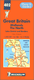
Carte routière
: Midlands - Angleterre du Nord n° 402, 1/400000 Angleterre Nord. Index des localités et agrandissements de Birmingham, Leeds, Liverpool, Manchester. An annually updated road map of the Midlands and the North of Great Britain, covering the main and secondary road networks across the region. Scale: 1/400,000 - 1cm=4km - 1in : 6.30miles Legend/Key in four languages (English, French, German, Dutch) Michelin Editions des Voyages (Régions Pays Grande Bretagne) |
|
|
scale 1:1.000.000
Royaume-Uni |
United Kingdom
Administrative Boundaries Wall Map
Ordnance Survey |
|
|
British Isles
Communication Map
Wall Map - Carte murale British Isles Communication Sheet Size: 935 mm by 1,040 mm Ordnance Survey |
|
|

|
Gran Bretaña (en
espagnol)
Disfrute del carácter único de esta isla, de sus múltiples facetas y de una forma muy particular de ver la vida, en la que la modernidad se combina con siglos de tradición y con rasgos tan específicamente británicos como el sentido del humor, el fair play y la sutileza. La guía, práctica y completa, le invita a pasar buenos momentos en un país del que guardará un recuerdo imborrable. Broché - 520 pages -
Le Guide vert |
|

|
Gran Bretagna (en
italien)
Parchi e scogliere, la famiglia reale, la bombetta e l'ombrello, università millenarie, le tante Miss Marple che curano il giardino, ma hanno un guizzo ironico negli occhi, gli imprescindibili maggiordomi che ci ha raccontato Wodehouse... luoghi comuni, o forse no. Partiamo per scoprirlo. La redazione della guida ha pensato a voi : sul posto e per voi ha assaggiato le specialità regionali, ha scovato indirizzi simpatici, ha studiato itinerari per escursioni a piedi e in auto. Broché - 520 pages -
Le Guide vert |
|

|
Grande Bretagne
Pour percer le caractère de ce royaume insulaire, apprêtez-vous à découvrir ses faces cachées et à tester un mode de vie où le célèbre humour britannique et la courtoisie contribuent à tempérer les effets d’une modernité confrontée à des siècles de traditions. LE GUIDE VERT a pensé à vous : sur place et pour vous il a déniché des lieux sympathiques, a préparé des circuits de découverte inédits et originaux. Broché - 532 pages -
Le Guide vert Travel and tourism |
|

|
Grossbritannien (en allemand) GroßBritanien - Karten und Pleine Um die Einzigartigkeit des Inselreiches wirklich zu genießen, machen Sie sich auf seine unbekannten Seiten und einen Lebensstil gefaßt, in dem der moderne Alltag nicht nur von jahrhundertealten Traditionen, sondern vor allem von britischem Humor, Fair Play und Understatement geprägt ist. Wir, das Redaktionsteam der Kollektion DER GRÜNE REISEFÜHRER, haben für Sie vor Ort Rundfahrten und Wanderrouten ausgearbeitet und weitere wertvolle Reisetips zusammengestellt. Broché - 520 pages -
Le Guide vert |
|

|
Groot
Britannië (en néerlandais) Wie sich openstelt voor de vele aspecten van het unieke karakter van Groot-Brittannië, zal ervaren dat de moderne, hedendaagse levensstijl van de Britten niet alleen duidelijke sporen vertoont van eeuvenoude tradities, maar ook wordt gekenschetst door een geheel eigen vorm van humor, door fair play en understatement. - Cartografie Broché - 520 pages -
Le Guide vert |
|

|
Great Britain
& Ireland 2002
Dans l'édition 2002 : 4690 hôtels et B & B 1534 restaurants dont 107 « Bib Gourmand » (les bonnes adresses à petits prix) et 263 pubs millésime : 2002 Légende en : Anglais Allemand Italien Français Guides Rouges |
|

|
AA Glovebox Atlas
Britain With 82 Town Plans
This practical atlas provides 83 town plans with recommended through-routes indicated. Motorways, primary roads and A and B roads are all marked and toll roads highlighted. The ferry routes, airports, national and county boundaries are also shown. Spirales - 192 pages - AA Publishing |
|

|
The AA Hotel Guide
2002
Paperback - 912 pages - 215 x 150mm This guide details over 4000 AA inspected hotels in England, Scotland, Wales, Ireland, the Channel Islands and the Isle of Man. New features to this 35th edition include highlighted listings for hotels with spas and those offering leisure breaks. AA Publishing |
|

|
AA Bed &
Breakfast Guide
Paperback - 706pages - 217 x 148mm A full-colour guide to over 3000 inspected guest houses, farmhouses and inns in England, Scotland, Wales and Ireland, this reference is arranged by county and town order and features the Diamond Quality Standards Assessment developed with English Tourist Board and the RAC. AA Publishing |
|

|
AA the Restaurant
Guide 2002
Paperback - 758 pages - 215 x 148mm Highlighting outstanding wine lists and featuring the 2002 winners of the Chef's Chef of the Year, Restaurant of the Year and AA Wine Awards for England, Wales and Scotland, this guide details over 1800 top restaurants recommended by the AA for their culinary excellence. AA Publishing |
|

|
AA Road Map South
West England
This map of South West England shows motorways, dual carriagways, and local roads and includes information on service areas, road numbers, tunnels and passes, ferry routes, railways, and national and administrative boundaries. It also indicates places of interest and national parks.
|
|

|
AA Road Map South
East England
This map of South East England shows motorways, dual carriagways, and local roads and includes information on service areas, road numbers, tunnels and passes, ferry routes, railways, and national and administrative boundaries. Sheet map (folded) - 253 x 118mm AA Publishing
|
|

|
AA Road Map North
East England
Sheet map (folded) - 254 x 119mm This map of North East England shows motorways, dual carriagways, and local roads and includes information on service areas, road numbers, tunnels and passes, ferry routes, railways, and national and administrative boundaries. It also indicates places of interest and national parks. AA Publishing |
|

|
AA Road Map
Northern England
This map of Northern England shows motorways, dual carriagways, and local roads and includes information on service areas, road numbers, tunnels and passes, ferry routes, railways, and national and administrative boundaries. Sheet map (folded) - 253 x 118mm AA Publishing |
|

|
AA Road Map
Central Southern England
This map of Central Southern England shows motorways, dual carriagways, and local roads and includes information on service areas, road numbers, tunnels and passes, ferry routes, railways, and national and administrative boundaries. Sheet map (folded) - 253 x 118mm AA Publishing |
|

|
AA Road Map
Britain
This map of Britain shows motorways, dual carriagways, and local roads and includes information on service areas, road numbers, tunnels and passes, ferry routes, railways, and national and administrative boundaries. It also indicates places of interest and national parks. AA Publishing Travel and tourism |
|

|
AA Great Britain
Road Atlas
Featuring battleship grid and a listing of the most difficult restricted motorway junctions, this road atlas of Britain is fully updated with over 3000 changes and includes 100 places of interest and 20 airports in the index of over 31,500 entries. Carte - mapa - kaart - karten AA Publishing |
|

|
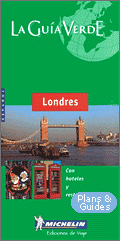
Country Guide
Londres
- Central London - Chelsea - Earl's Court - South Kensington - Bloomsbury - Strand - Leicester - King's Cross - Covent Garden - West End - Mayfair - Oxford Street - Soho - Paddington Bayswater - Notting Hill - City of London - East-End - Hammersmith - Kensington - Notting Hill Gate - Holland Park - Windsor - Stonehenge 8 Bath - Warwick Castle & Oxford - Leeds Castle - Canterbury - Dover - Greenwich - Ecluses de la Tamise Broché - 284 pages |
|

|
Londres de Guide
Gallimard
Broché - 206
pages |
|

|
Londres, 2002
Editeur : Hachette tourisme |
|
|
Londres (en
espagnol)
Para apreciar los encantos de esta ciudad en permanente expansion, se recomienda explorar los numerosos pueblos que la componen, cada uno de ellos mit mis con sus caracteristicas distintivas~lls; mezclarse con la gente en los pubs tradicionales, visitar los animados mercados, contemplar la pompa de las ocasiones de estado, ir a un partido de futbtol, un concierto de musica pop o un espectaculo teatral al aire libre. ... Broché - 414 pages |
|

|
AA Street by
Street London & South East England
The drivers bible, with every named street in London and the South East. Easy-to-read street names, prominent landmarks and good use of colour are just some of the features that make this Britain''s clearest street mapping. It has a base scale of 3.94 inches to 1 mile (1:25,000), with 130 pages of urban areas at an enlarged scale of 4.2 inches to 1 mile (1:17,500). There are plenty of details for motorists, with clearly marked one-way streets, petrol stations and car parks, whilst clever use of colour ensures that it can be read under street lighting. AA Publishing |
|

|
AA Street by
Street London Mini - Plan de Londres
A ground-breaking new street atlas of London. Easy-to-read street names, prominent landmarks and good use of colour are just some of the features that make this Britain''s clearest street mapping. This practical wiro has a base scale of 3.6 inches to 1 mile (1:17,500). AA Publishing |
|

|
Ecosse - n°401,
1/400000 de Carte
Michelin
Ecosse. Index des localités et agrandissements de Edinburgh, Glasgow. An annually updated road map of Scotland, covering the main and secondary road networks across the region. Scale: 1/400,000 - 1cm=4km - 1in : 6.30miles Legend/Key in four languages (English, French, German, Dutch) Carte Michelin Editions des Voyages |
|

|
AA Road Map
Scotland
This map of Scotland shows motorways, dual carriagways, and local roads and includes information on service areas, road numbers, tunnels and passes, ferry routes, railways, and national and administrative boundaries. Carte - mapa - kaart - karten AA Publishing |
|

|
Ecosse
Promenez vous dans les Highlands au son des cornemuses Les légendes vont bon train au sujet de l'Ecosse et il est bon de s'y rendre pour voir, de ses yeux voir, que les paysages fascinent plus que les fantômes et leurs chaînes... Broché |
|

|
AA Street by
Street Glasgow Midi
A ground-breaking new street atlas of Glasgow. Easy-to-read street names, prominent landmarks and good use of colour are just some of the features that make this Britain''s clearest street mapping. This handy-sized softback includes coverage of Clydebank, Coatbridge, East Kilbride, Hamilton, Motherwell, Paisley, Airdrie, Barrhead, Bridge of Weir, Cambuslang, Cumbernauld, Dumbarton, Johnstone, Kilsyth, Kirkintilloch and Milngavie and has a base scale of 4.2 inches to 1 mile (1:15,000). |
|

|
AA Street by
Street Edinburgh Midi
A ground-breaking new street atlas of Edinburgh. Easy-to-read street names, prominent landmarks and good use of colour are just some of the features that make this Britain''s clearest street mapping. This practical wiro includes coverage of Cockenzie and Port Seton, Dalkeith, Gorebridge, Musselburgh, Penicuik, South Queensferry, Balerno, Bonnyrigg, Currie, Kirkliston, Leith, Loanhead, Newtongrange, Prestonpans, Tranent and Winchburgh and has a base scale of 4.2 inches to 1 mile (1:15,000). |
|
|
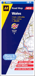
AA Road Map Wales
This map of Wales shows motorways, dual carriagways, and local roads and includes information on service areas, road numbers, tunnels and passes, ferry routes, railways, and national and administrative boundaries. |
|

|
AA Street by
Street Cardiff, Swansea, Newport Maxi
A ground-breaking new street atlas of Cardiff, Swansea and Newport. Easy-to-read street names, prominent landmarks and good use of colour are just some of the features that make this Britain''s clearest street mapping. This large format, practical wiro atlas includes coverage of Bridgend, Cwmbran, Llanelli, Merthyr Tydfil, Neath, Port Talbot, Aberdare, Barry, Caerphilly, Ebbw Vale, Maesteg, The Mumbles, Penarth, Pontypool, Pontypridd and Porthcawl and has a base scale of 3.6 inches to 1 mile (1:17,500). |
|

|
Pays de Galles
CARDIFF/CAERDYDD Broché - 191 pages |
|

|
Angleterre Pays
de Galles
Ce pays où les pelouses sont si vertes qu'on à peine à croire qu'elles sont naturelles, n'est qu'à une trentaine de kilomètres de nos côtes, un bras de mer ou un tunnel nous en sépare. Tout y est net, offrant à chacun un espace raisonnable pour vivre même si la population britannique, aussi nombreuse que la française, dispose de moitié moins de surface totale. La jeunesse qui, il y a plus de trente ans, a fait craquer l'austérité victorienne, est toujours aussi originale et vivante. En faisant cohabiter tradition et modes de tous bords, chapeau melon et jupes de cuir, la Grande Bretagne a bien évolué. Les Beatles sont déjà de l'histoire ancienne...Au pays de Galles, des moutons, certes, mais aussi la mer, la plage, montagnes, et châteaux : ce pays à l'aspect si sauvage vous surprendra ! Editeur : Hachette tourisme |
|

|
Camping &
Caravan Parks in Britain : 2002
Paperback - 288pages - 232 x 148mm 16pp colour map Carte - mapa - kaart - karten English Tourism Council |
|
|
Royaume-Uni
- Großbritannien
- United
Kingdom sur
|


|
|
|
|
|
|
|
|
|
|
|
Copyright © 2001-2005 |
|
|
|
|
Plans &
Guides -
Tourisme -
Road
Map -
Tourism |
|

