|
|
Destination :
Colorado - USA - US
Tourism and Travel
- Tourisme - Voyage - Reiseführer nach Reihen
United States of America -
États-Unis d'Amérique - Vereinigte Staaten von Amerika
|
|
|
|
|
|
|


 |
Colorado Atlas and
Gazetteer
DelormeWith an incredible wealth of detail, DeLorme's Atlas & Gazetteer®
is the perfect companion for exploring the Colorado outdoors. Extensively
indexed, full-color topographic maps provide information on everything
from cities and towns to historic sites, scenic drives, trailheads, boat
ramps and even prime fishing spots.
A handy latitude/longitude overlay grid for each map allows you to
navigate with GPS. Conveniently bound in book form, the Atlas & Gazetteer®
is your most comprehensive guide to Colorado's backcountry.
Detail commonly includes:
-
Back roads, dirt roads and trails
-
Elevation contours
-
Remote lakes and streams
-
Boat Ramps
-
Public lands for recreation
-
Land use / land cover – forests,
wetlands, agriculture
-
Trailheads
-
Campgrounds
-
Prime hunting and fishing spots
Typical Gazetteer categories
include:
Each gazetteer entry's location is
cross-referenced to the corresponding map.
Rand McNally & Company
|


 |
|
|

 |
|
|
|
|

|
Colorado - National
Geographic Guide Map More than the usual folded state
map, National Geographic's Guide Map for Colorado offers detailed
statewide coverage as well as destination info in a portable format.
It has suggestions for things to see and do, with listings of sights,
events, scenic drives, and much more. Inset maps and highway maps will
help you get from place to place, and the descriptions will provide ideas
for spontaneous detours. It's a great road trip companion. Measures 9" x
4" folded.
Publisher: MapQuest.com
Rand McNally & Company |

|
|
|

|
Colorado - Rand McNally
EasyFinder Map Durable, convenient Rand McNally EasyFinder®
maps will take all the wear and tear your journey can dish out. The map
easily folds to display individual sections, and eliminates the headache of
refolding a paper map in the car. The laminated design allows you to mark
your route, make notes, then wipe the surface clean for further use.
The Colorado EasyFinder® features clearly indicated highways, county
boundaries, streets, points of interest, national parks, and more, with a
quick-reference legend and a city index. It's a must-have for navigating the
state whether you're a resident or just passing through.
Publisher: Rand McNally
Travel & Holiday guides
Guide de voyage -
Travel Guide
Landkarte |
|
|
|
 |
|
|
|
|
 |
The Colorado Guide - Fulcrum
Now in its fifth edition,
The Colorado Guide remains
the single most reliable resource for discovering and rediscovering
Colorado’s well-known landmarks and its best-kept secrets. This
comprehensive guidebook features more than 1,500 things to see and do
throughout Colorado, complete with full-color maps and photographs. Written
with an insider’s perspective by two native Coloradans,
The Colorado Guide provides detailed
information on:
- Outdoor activities such as hiking,
backpacking, biking, fishing, boating, and skiing
- Regional history and attractions,
including local festivals, historic sites, and museums
- State and national parks, national
forests, and wilderness areas
- Scenic drives, including four-wheel-drive
and motorcycle trips
- Restaurants, nightlife, and shopping
- Accommodations for every budget, from
hotels and bed-and-breakfasts, to campgrounds and RV parks
- Up-to-date contact information, including
toll-free numbers and websites
Publisher: Fulcrum Publishing |
|
|
|

|
USA - Colorado Plateau
/ Canyonlands
Südliche Rocky Mountains
Southern Rocky Mountains
1:700.000
Doppelseitig.
Ortsverzeichnis.
Übersichtkarte USA - Südwest 1:3.500.000
Road map - Carte routière
Landkarte - K+G Karto + Grafik
Publisher: Hildebrand's Maps |

|
|
|

|
|
|
|
|
 |
Colorado's Best: The
Essential Guide to Favorite Places
Travel the back roads and
blue highways of Colorado to proven destinations and activities!
From the bestselling coauthor of
The Colorado Guide and
the writer/producer of KCNC News 4’s award-winning TV show
Colorado Getaways comes
a must-have collection of recommended places to go and experiences to have
in Colorado. Visitors and residents alike will appreciate this essential
guide, with its personal, authoritative selections. The riches within
include:
- Plenty of family-friendly outings, all carefully identified throughout
the book
- An easy-to-follow organization
By region
- Eastern Plains, Front Range, South Central, North Central, Southwest,
and Northwest; and
- By activity
- Cultural and Historical; Outdoor
Activities & Events; and Where to Eat, Drink and Stay.
- Hidden gems and out-of-the-way places, together with some of the
better-known choices in the states.
- Interesting, descriptive writing, combined with photographs, to help
you chart your course and pick your pleasure.
Whether you want to be dazzled by butterflies at
Westminster’s Butterfly Pavillion, don your waders for some fabulous fly
fishing on the Frying Pan River, fly down the slopes at the best ski area,
or find the best small-town dining in Southwest Colorado,
Colorado’s Best will
share these highlights and much more!
Publisher: Fulcrum Publishing |
|
|
|
|
|
|
|
|

|
Denver - Rand McNally Folded
Map Rand McNally folded maps have been the
trusted standard for years, offering unbeatable accuracy and reliability at
a great price. This folded map shows all Interstate, U.S., state, and county
highways for the Denver area, with clearly indicated parks, points of
interest, airports, county boundaries, streets, and more. Inset maps are
included for Central Denver and Denver International Airport.
Detailed indices make for quick and easy location of destinations. It's a
must-have for anyone traveling in and around this part of Colorado. Measures
9.5" x 4" and folds out to 40" x 28".
Communities covered:
- Arvada,
- Aurora,
- Bow Mar,
- Broomfield,
- Centennial,
- Cherry Hills Village,
- Columbine Valley,
- Commerce City,
- Englewood,
- Federal Heights,
- Foxfield,
- Golden,
- Greenwood Village,
- Lakewood,
- Littleton,
- Lone Tree,
- Morrison,
- Northglenn,
- Sheridan,
- Thornton,
- Westminster, and Wheat Ridge.
Rand McNally & Company |
|
|
|
|
|
|
|
|
City map USA
Plan de ville USA |
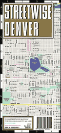
 Denver Streetwise
de Streetwise Map
Plan de Ville de Denver
La ville, le centre-ville et toute la région
sur le même titre. Egalement Boulder sur ce titre.
Plastifié,
clair, lisible, esthétique, pratique et complet (index avec liste des rues,
hôtels, sites touristiques, musées, monuments, shopping, etc.).
Denver Streetwise
Laminated for
durability, accordion folded to fit in your pocket or purse,
Streetwise (r) gives you Denver in a clear, concise, and convenient
format.
City map - Town Plan
Stadtplan - Plan de ville |

|
|
|

|
Western United States - Rand
McNally Folded Map Rand McNally's
redesigned folded map for the Western US features enhanced cartography
showing all Interstate, U.S., state, and county highways, along with clearly
indicated parks, points of interest, airports, county boundaries, and
streets. The easy-to-use legend and detailed index make for quick and easy
location of destinations.
Rand McNally folded maps have been the trusted standard for years,
offering unbeatable accuracy and reliability at a great price. This one's a
must-have for anyone traveling in and around the Western US.
Covers
- Arizona,
- California,
- Colorado,
- Idaho,
- Montana,
- Nevada,
- New Mexico,
- Oregon,
- Utah,
- Washington
- Wyoming.
Insets of major cities and a mileage chart are included.
Rand McNally & Company
|
|
|
|
|
|
|
|
|

|
Denver Regional - Rand
McNally StreetFinder Atlas Rand
McNally's StreetFinder® atlas for regional Denver is the definitive auto
companion for travel in this part of Colorado, whether you are a resident or
short-term visitor. It's got all the features to make even the unfamiliar
regions easy to navigate.
- High quality full-color maps
- Comprehensive street-level detail in an easy to follow grid design
- Clearly indicated points of interest
- Hospitals, schools, shopping areas, and much more marked on the maps
- Detailed zip code, block number, and highway exit number info
- Spiral binding allows the atlas to lay flat - perfect for the car
- PageFinder™ indexing system provides quick and easy access to whatever
specific area you seek.
- Dimensions: 10.75" x 8"
Communities covered: Arvada, Aurora, Bennett,
Black Hawk, Boulder, Brighton, Broomfield, Byers, Castle Rock, Centennial,
Central City, Cherry Hills Village, Columbine Valley, Commerce City, Denver,
Edgewater, Elizabeth, Englewood, Federal Heights, Glendale, Golden,
Greenwood Village, Idaho Springs, Jamestown, Kiowa, Lafayette, Lakewood,
Larkspur, Littleton, Lone Tree, Longmont, Louisville, Lyons, Morrison,
Nederland, Northglenn, Parker, Sheridan, Superior, Thornton, Ward,
Westminster, and Wheat Ridge.
Rand McNally & Company |
|
|
|
|
|
|
|
|


 |
Topo USA 5.0 National DVD
DeLorme Topo USA 5.0 DVD
DeLorme Topo USA 5.0 gives you amazing
tools to help plan your outdoor adventures, on and off the road. Brilliant,
detailed topographical mapping is provided for the entire U.S., complete
with elevation data, rivers and streams, and more than 300,000 trail miles.
Topo 5.0 offers many new and updated features that make it the best version
yet of Topo USA. This DVD version means no switching discs when you need to
access different information!
- Create automatic routes by trail or road
- Automatically download your GPS track files as routable roads or
trails
- New 3-D views let you look around from where you stand as well as out
to where you're heading; You even can see the free imagery rendered on a
realistic 3-D map
- Customize and print maps to take along or help plan
- Get profiles for roads, trails, and waterways
- Use freehand drawing tools to trace routes on the maps
- Includes the most recent national street network available from
DeLorme
- Free CD included shows breathtaking aerial imagery of a variety of
national places of interest
- Access and download DeLorme campground information from 16,107 State
and National Parks
- FREE download of $50 worth of Aerial Data Packets (ADPs), including
up-to-date aerial photos (DOQQs), 10-meter color satellite images, and
scanned USGS 7.5-minute topographic maps (free downloads only available
via Web download from the DeLorme 4-terabyte server)
Topo USA makes it easy and fun to plan camping trips, hikes, or
just about any other excursion.
System requirements: Microsoft® Windows® 95/98, or Windows NT® 4.0 or
later; PC with Intel® Pentium® 150 or higher processor; 32 MB RAM; 300 MB of
RAM of available hard-disk space; DVD-ROM drive; 16-bit color monitor with
Super VGA graphics; mouse.
DeLorme |
|
|
|
 |
|
|
|
|
|
|
|
|
|

|
USA
phrasebook, (en anglais)
de Lonely PlanetFrom
Tinseltown's glitter to the charm of the South, decode the jargon and
discover the culture of the USA. Compare Big Apple speed-speech with the
laidback Texan drawl. Identify the multitude of regional and social
dialects and influences on the language along the way.
- learn to order a splash of red noise in a diner or request your
coffee unleaded
- understand dialects from SoFlo to Yooper, and hear the echoes of
Shakespeare
- expand your musical horizons with a comprehensive guide - from
rock'n'roll to techno
- immerse yourself in the language melting pot - from US Spanish &
Asian languages to African-American English & Yiddish
- includes Native American languages & Hawaiian
Phrasebooks
Phrasebooks cover the essential words and phrases travellers may need.
These pocket-sized language guides include colour tabs for quick reference,
extensive vocabulary lists, easy-to-follow pronunciation keys and two-way
dictionaries.
Editeur : Lonely Planet
Travel & Holiday guides |
|
|
|


|
Anglais ou Américain ? Les
différences à connaître
L'anglais britannique et l'anglais américain, deux variantes d'une même
langue qui se distinguent par le vocabulaire, l'orthographe, la
prononciation et, sur certains points, par la grammaire. Cet ouvrage a
pour vocation de vous permettre de passer rapidemment de l'un à l'autre et
d'éviter ainsi les incompréhensions que ces différences peuvent provoquer.
Un guide de 94 pages
Guide de conversation
Editeur Assimil
Collection Langue De Poche |
|
|
|
|
| |
|
|

Livre + 4 CD Audio
|
L'Américain sans peine
Assimil - Collection Sans PeinePour tous
ceux qui veulent se servir dès le départ de l'anglais américain comme
langue internationale, Assimil a créé cette authentique (et humoristique)
introduction à la langue et à la culture américaines. Tout en vous
enseignant la langue, notre méthode vous donne un aperçu plus familier du
pays et de ses habitants.
Un livre relié-cousu de 105 leçons en 608 pages et 4 CD d'une durée de
2h45
Débutant, Faux débutant, Remise à niveau
Collection "Sans peine"
Série essentielle d’ASSIMIL, elle permet en quelques mois d'acquérir
plus 2000 mots de vocabulaire, la grammaire de base et de maîtriser la
conversation courante dans plus de cinquante langues.
Editeur Assimil - Langue
Collection Langue Sans Peine |
|
|
|

|
Pack Tell Me More Anglais,
niveaux 1+2+3
AuralogTell Me More, véritable
logiciel intelligent capable d'analyser vos progrès en temps réel, vous
proposera l'activité la plus pertinente par rapport à vos besoins.
Quels que soient vos objectifs et votre niveau, du vrai débutant au
professionnel confirmé, Tell Me More s'adapte à vos besoins et accompagne
vos progrès tel un véritable professeur de langues. Des parcours de
travail dédiés à la préparation des Certificats Européens de Langues vous
permettront de vous entraîner selon les niveaux définis par le Conseil de
l'Europe.
Référence mondiale des logiciels d'apprentissage de
langue étrangères, Tell Me More est à la fois apprécié par les
professionnels de l'enseignement pour son utilisation intensive de la
reconnaissance vocale ainsi que ses parcours pédagogiques pour un
apprentissage personnalisé : le Ministère de l'Education Nationale a
décerné le label " Reconnu d'Intérêt pédagogique " à la version éducation
de Tell Me More pour plusieurs langues.
Approche pédagogique à la carte -
3 modes de travail :
- Mode Libre
(pour un apprentissage à votre convenance),
- Mode Guidé
(en fonction de vos priorités d'apprentissage et vos disponibilités),
- Mode Dynamique
(optimise l'apprentissage en s'adaptant à vos progrès et vos objectifs
de départ)
Contenu riche et varié
750 heures d'apprentissage
37 types d'activités (sur les ateliers Thématique, Culture, Grammaire,
Vocabulaire, Oral et Ecrit)
Tutorat gratuit en ligne (les tuteurs du forum Club Auralog complètent
votre apprentissage en cas de question)
Technologies de dernière génération
Reconnaissance vocale de référence (Le système S.E.T.S.
vous permet de retravailler vos erreurs de prononciation)
Vidéo et dialogues interactifs
Interface moderne et ergonomique
|
3 niveaux |
Années d'études
de la langue
|
Equivalence scolaire
|
|
Débutant
|
0-2
|
COLLÈGE
|
|
Intermédiaire
|
2-4
|
LYCÉE
|
|
Confirmé
|
4 +
|
Bac à Bac +2
|
3 niveaux
- Débutant
(0 à 2 ans d'études de la langue, Niveau A1/A2 du Certificat Européen de
Langues, niveau Collège)
- Intermédiaire
(2 à 4 ans d'études de la langue, Niveau B1 du Certificat Européen de
Langues, niveau Lycée)
- Confirmé
(4 ans d'études de la langue, Niveau B2 du Certificat Européen de
Langues, niveau Bac à Bac +2)
Editeur : AURALOG
Educatif / langues / Anglais |
|
|
|
 |
|
|
|
|

|
|
|
|
|
 |
|
|
| Colorado
- CO - USA Capitale :
Denver
|
|
Cities - Cities and
Towns - Villes
Alamosa,
Arvada,
Aspen,
Aurora,
Avon, Beaver Creek,
Boulder,
Breckenridge,
Brighton,
Broomfield,
Brush,
Buena Vista,
Burlington, Calhan,
Canon City,
Carbondale,
Cascade,
Castle Rock,
Cheyenne Wells,
Colorado Springs, Copper Mountain,
Cortez,
Craig,
Crested Butte,
Cripple Creek,
Cuchara, Delta, Denver,
Dillon, Durango, Eagle,
Edwards,
Englewood,
Estes Park,
Evans,
Evergreen, Florence,
Fort Collins,
Fort Morgan, Fountain,
Fraser,
Frisco, Georgetown,
Glendale,
Glenwood Springs,
Golden,
Granby,
Grand Junction,
Greeley,
Gunnison, Henderson, Keystone, La Junta
Lakewood,
Lamar,
Las Animas,
Leadville,
Limon,
Littleton,
Longmont,
Louisville,
Loveland, Mancos,
Manitou Springs,
Mesa Verde,
Minturn,
Monarch,
Monte Vista,
Montrose,
Morrison, Nederland,
Northglen, Ouray, Pagosa Springs,
Parachute,
Pueblo,
Pueblo West, Red Cliff, CO Rocky Ford, Salida,
Security,
Silverthorn,
Snowmass Village,
Springfield,
Steamboat Springs,
Sterling, Telluride,
Trinidad, Walsenburg,
Westminster, Wheatridge,
Winter Park,
Woodland Park. |
|
|
|
|
|


 |
|
 |


